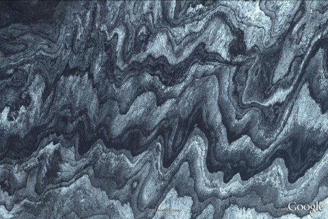
It seems I'm back on track with playing WoGE, although not always successful. (For a description what this is, see below the fold. Previous WoGEs are collected on Felix Bossert's blog and in Ron Schott's KML.)
But this time I was lucky and found Felix Bossert's remake of WoGE 122, a close-up view of dunes in the Apure River region of Venezuela – now called WoGE 273. I think I only had a chance because the accidental double-post prevented both Ron Schott and Péter Luffi from taking part.
The last WoGE was quite like a painting, and so I want to continue with nice-looking images. Is this a close view of a metamorphic rock? Who knows…
For any new players to Where on (Google) Earth, simply post a comment with latitude and longitude and write something about the (geologic) feature in the picture. If you win, you get to host the next one.
I'm not sure if this is easy or not. To be on the safe side, I invoke Schott's Rule: former winners have to wait until posting for 1 hour for each WoGE they got right. I will post some hints (e.g. a scale bar) if there is no answer after some time.
Posted on 10 March, 21:00 CET (20:00 UTC).
Have fun and good luck!


Comments 11
Sieht so aus als ob wir nun quitt (Donauversickerung) sind! Auch ich habe diesen Ort seit Matt Halls Schlammvulkan auf meiner Liste. Allerdings wollte ich etwas Gras darüber wachsen lassen... Das Bild ist wirklich außergewöhnlich! Nachdem ich mit meinen Kids am Wochenende nach München ins Deutsche Museum gehe und ich sowieso zuviel Woges auf meinem Kerbholz habe, halte ich mich mal wieder zurück. Viele Grüße an die Ostsee.
Na großartig. 😉
Viel Spaß im Deutschen Museum! Ich war letztes Jahr endlich mal wieder da, und da wurde recht viel umgebaut. Der Bereich Rohstoffe/Bergbau war aber noch ziemlich alt und schon etwas marod. :-/ Das war grad die Zeit des Deepwater-Horizon.Debakels, da hätten die schon mal den ausgestellten Blowout Preventer mit aktueller Information versorgen können. (Etwas nach meinem Besuch ging es dann an die Rettung der Bergleute in Chile, ich hoffe, sie haben was an der ausgestellten Dahlbusch-Bombe gemacht.)
„An die Ostsee“? Hier müsste es wenn schon „an den Ostsee“ heißen, aber der ist ja noch gar nicht da. 😉
Na alles nördlich des Mains ist entweder Ost- oder Nordsee. Da kommts auf 100km auch nicht drauf an.
To my English-speaking readers:
Felix just told me that I've taken away his planned WoGE; same as he did to me with his WoGE 269.
In contrast to me, however, he had the decency of not taking part in this challenge. (Because, he admitted, he solved too many WoGEs already.)
So everybody, have a go at it!
Ignore the rest of our comments, we were just talking about the Deutsches Museum.
Felix, da bin ich aber mal froh, daß Du kein Oberstdorfer bist und gnädigerweise den Main zählen lässt, und nicht die Breitach. 😉
Die Breitach läuft hier unter Norditalien.
64°22"N
16°15"W
Iceland. This took me all of 5-10 minutes. Maybe a bit of luck, too. It kinda looked volcanic. Kinda looked like a glacier. I also thought it might be some bedrock scoured by ice age glaciers. I took a quick look at a couple spots in Africa then moved to Iceland. Was contemplating Hawai'i and the Canadian Shield next.
Anyway, the geology. This is on the north side of the Vatnajökull glacier, underneath which are some volcanoes. I'm wondering if this may be some evidence of subglacial eruptions. Layers of volcanic ash alternating with ice.
I'm going to go do some digging so I can give a better answer, but I just wanted to make sure I get my post in.
Brian
Some more information.
This specific area is the Brúarjökull glacier, one of the outlet glaciers of the Vatnajökull ice cap. This glacier is a sub-type known to experience glacial surges, where the speed of the glacier increases up to 100 times the normal speed. The glacier can advance several tens of kilometers before returning to it's normal flow rate. While in the quiescent phase the glacier retreats, leaving behind a variety of unusual landforms.
Brúarjökull glacier was the focus of a recent study into glacial surges and the landforms resulting from them. It is known to have surged in 1810, 1890 and 1964.
http://notendur.hi.is/oi/bruarjokull_project.htm
Brian
Sorry for replying so late – I'm ill and didn't feel very much like using the computer the last days.
Brian, you're right, of course, and thanks for the additional info.
I hoped that my image would be less obviously glacial (as e.g. WoGE 215) and last a bit longer than just 3 hours…
Brian, we're looking forward to your WoGE 275!
Sorry to hear of you feeling ill. Hope you fell better now. I figured everyone was caught up in the disaster in Japan.
In the mean time I have been setting up a blog of my own so I can host WoGE's rather than expecting others to do so for me.
I will post my WoGE in about one hour at 2100 GMT, and post a reminder here at that time.
My blog is located at: http://www.skywise711.com/blog/
I've only set it up in the past couple of days so if there are any problems please let me know. I've never done a blog before.
Brian
WoGE #275 is now online at http://www.skywise711.com/blog/
Brian
Post a Comment