Sprache ändern mit den Flaggen oben links.
Change the language with the flags on the top left.
Sprachschalter / Language Switch
Mono und solo!
Nachdem ich Mono im Dezember in Dresden leider nicht live sehen (und vor allem hören!) konnte, freue ich mich um so mehr auf dieses edle Prachtstück: Mono – “The Last Dawn / Rays Of Darkness Tour” Photo-Book + 2×CD.

Facebook, nicht heftig
Gibt’s diese Option noch nicht so lange, oder habe ich sie einfach immer nur übersehen?
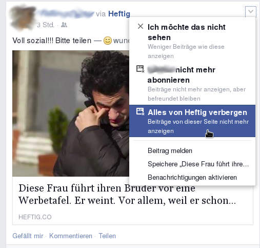
Ihr werdet nicht glauben, was nach dem „Weiterlesen“-Link kommt!
ZDF-Beitrag über Flüchtlinge im Allgäu
Am 10.03. sendet das ZDF in „37 Grad“ einen Beitrag über die Unterbringung von Flüchtlingen in Fischen, dem nächstgrößeren Nachbardorf meines Heimatorts.
„Jetzt können wir beweisen, wie gastfreundlich wir wirklich sind“, sagt Bernward Lingemann von der Verwaltung der Hörnerdörfer im Allgäu. Vor kurzem sind 36 Flüchtlinge, Männer aus Syrien und Afghanistan, in Fischen in die alte Dorfwirtschaft im Ortsteil Au eingezogen. 37 Grad beobachtet von November 2014 bis Februar 2015 das kleine Dorf im Allgäu mit seinen alten und neuen Bewohnern.
Von der Unterbringung in dem ehemaligen Gasthaus hatte ich schon erfahren, aber daß gleich das ZDF anrückt hätte ich nicht gedacht. Ich bin gespannt, wie der Bericht so wird. Es gibt zwei kleine Vorschauschnippsel, aber da kann man noch nicht viel sagen.
Weißwurstfrühstück
Weil so ein schöner Sonntag ist, haben wir uns etwas gehen lassen und statt des Frühstücks uns zur Mittagszeit gleich Weißwürste, Brezen und Weizen munden lassen.
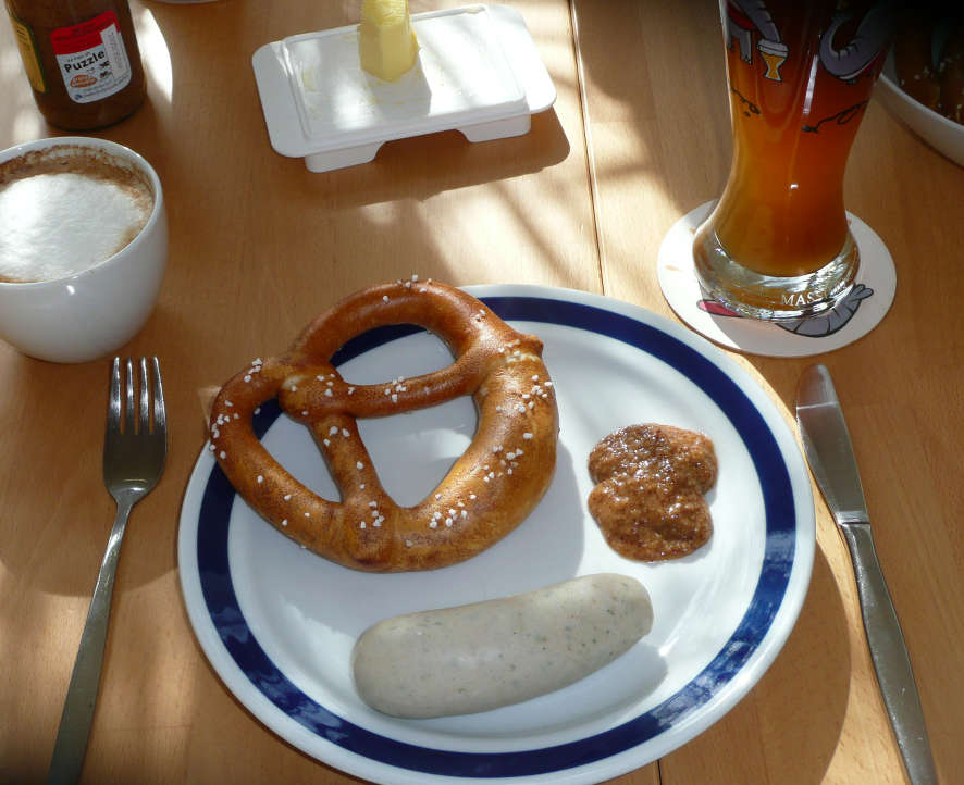
Der gemütliche Start in den Sonntag Mittag.
Schlauchpumpen
Wenn ich mir diesen Artikel von Holger Klein durchlese, hab ich das Gefühl, wir haben unsere Schlauchpumpen im Labor immer falsch eingesetzt. Und dabei hatten wir ja sogar hochprozentigen Alkohol greifbar…

Cocktailroboter. Bild von Holger Klein / Stackenblochen.
Facebook-Plugin
Leider gibt es das Wordbooker-Plugin, das WordPress-Artikel auf Facebook veröffentlicht und Kommentare synchronisiert hat, nicht mehr. Der Autor war sowohl von überanspruchsvollen Nutzern als auch der sich ändernden Facebook-API genervt und hatte auch keinen Spaß mehr daran, es weiter zu programmieren. Ich find das ziemlich schade.
Gibt es noch ein vergleichbares Plugin? Ich will nicht mein Blog facebookisieren, wie ich es mit dem offiziellen Plugin könnte, sondern Artikel auf Facebook bekannt machen und die Kommentare von da auch im Blog erscheinen lassen.
15. Februar, mal wieder
Heute jährte sich der Bombenangriff zum 70. Male. Das Gedenken an solch ein Ereignis, bei dem es ja auch viele zivile Opfer – Cottbuser und Flüchtlinge – gab, ist eine heikle Angelegenheit. Wenn die NPD das unternimmt, kann aber nichts vernünftiges dabei herauskommen. Um die 50 (Je nach Quelle – ich hab gefunden: Lausitzer Rundschau ≈50, Twitter-User Sören Kohlhuber: 57) Nazis zogen vom Bahnhof zum Turnerdenkmal im Süden der Stadt. Von verschiedenen Gruppen (Cottbus bekennt Farbe, Cottbuser Aufbruch, Cottbus Nazifrei) wurden Gegendemonstrationen organisiert.
Demo 15.02.15, Bahnhofsbrücke
Intensiv-Demo-Woche in Cottbus

Am Sonntag jährt sich die Bombardierung von Cottbus (weitere Informationen im PDF vom Cottbuser Aufbruch), und die NPD wird wieder versuchen, das Gedenken für ihre Zwecke auszunutzen. Glücklicherweise gibt es auch dieses Jahr wieder mehrere sinnvolle Aktivitäten, v.a. die Demo von „Cottbus bekennt Farbe“, aber auch ein Konzert des Orchesters des Staatstheaters im Bahnhof.
Vorher noch, und zwar heute lädt der Cottbuser Pegida-Ableger „Cogida“ (Und ja, ich haben einen Muttersprachler gefragt, es heiß tatsächlich f***en, oder als Torero vom Stier aufgespießt werden.) zum ersten Mal zum „Abendspaziergang“. Auf ihrer Facebookseite sagen sie zwar „Wir arbeiten nicht mit NAZIS zusammen und sind auch keine! Wir folgen klar den Punkten des Positionspapieres der PEGIDA! Wir hassen weder Moslems, Juden oder Ausländer!“, aber im Angesicht des „GIDA“ im Namen hört sich das doch eher nach „man wird ja mal sagen dürfen“ und „meine besten Freunde sind X, aber“ an. Drum werd ich jetzt mal zum Altmarkt zur Gegendemo rübergehen.
[Update 12.02.15: Links ergänzt, kleinere Fehler korrigiert]
Blog lebt wieder
Seit langer Zeit ist hier nicht mehr viel passiert, mal aus Mangel an Zeit, mal aus Mangel an Themen. Aber Mitte September wurde dann mein Blog vom Provider vom Netz genommen, weil es Opfer eines DDoS-Angriffs wurde und durch die massenhaften Anfragen den Server lahmzulegen drohte.
Briefwahl
Ich weiß nicht, ob es eine gute Idee ist, auf die Briefwahlunterlagen dick „Wahlunterlagen“ zu stempeln. Das könnte vielleicht den einen oder anderen auf die Idee bringen, sich eine zweite Stimme zu mopsen… So schwierig dürfte es nicht sein, beim Wählen zwei Scheine in die Urne zu befördern.
Was mir die Informationszettel in den Unterlagen nicht verraten haben: kann ich die Wahlbriefe auch beim hiesigen privaten Briefdienst RPV einwerfen? Immerhin hat die Stadtverwaltung die Unterlagen auch damit verschickt, und die Briefkästen sind für mich günstiger zu erreichen (gleich an der Uni). Meint die Aufschrift „Entgeltfrei im Bereich der Deutschen Post“ auf den Briefen den geographischen Bereich, in dem es die Deutsche Post gibt, oder einfach nur die Deutsche Post? (Dann sollte es doch einfach „Entgeltfrei mit der Deutschen Post“ heißen.)
Sieht aus wie ein Perpetuum Mobile…
…funktiontiert aber. Und ist vermutlich auch noch legal: So funktionieren Cum-Ex-Geschäfte.
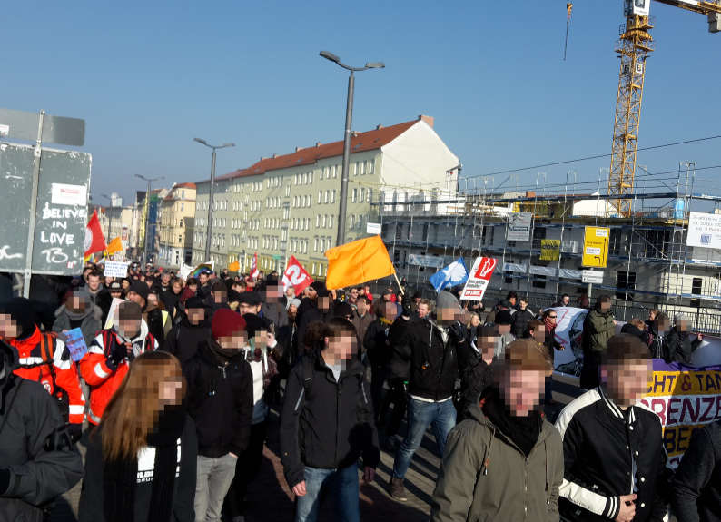
Demos gegen Neonaziaufmarsch
Wie leider jedes Jahr kommen morgen die NPD und ihre Gesinnungsgenossen wieder nach Cottbus, um anläßlich des Jahrestags der Bombardierung des Bahnhofs dafür zu demonstrieren, daß Frieden und Toleranz weithin überbewertet sind. Ihr vergleichbarer Aufmarsch in Dresden hat nicht ganz so gut geklappt, und es wäre schön, wenn das in Cottbus auch so wäre.
Die Initiative „Cottbus bekennt Farbe“ ruft wieder zu Gegendemonstrationen auf. Je nach persönlicher Neigung kann man sich den normalbürgerlichen, vom Cottbuser Aufbruch organisierten Veranstaltungen anschließen, oder – vermutlich etwas aufregender – mit „Cottbus Nazifrei“ dem Aufmarsch etwas entgegenzusetzen.
Der Cottbuser Aufbruch organisiert zwei Demonstrationszüge, die auf dem BTU-Zentralcampus und am Bahnhof beginnen und sich am Staatstheater treffen, sowie zahlreiche Aktivitäten verschiedenster Einrichtungen und Vereine. Als Gute Deutsche™ tauchen die Dumpfköpfe schon zeitig auf, und die Demos beginnen darum ungemütlich früh.
Cottbus Nazifrei hat die Aufmarschroute, die eigenen Kundgebungen, Infopunkt, Volxküche usw. auf dieser Karte zusammengestellt, außerdem gibt’s noch ein paar aktuelle Informationen für morgen.
Food-Carrier endlich wieder im Einsatz
Endlich mal kann ich mit dem Food-Carrier nach Jahren des nutzlosen Rumstehens relativ bestimmungsgemäß verwenden:
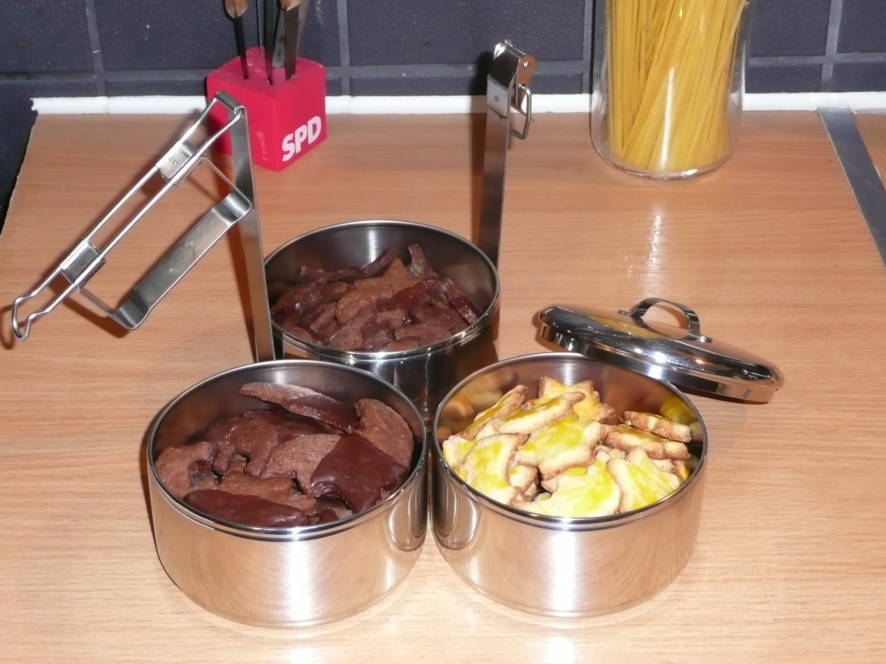
Ich hab’s endlich mal geschafft, ein bißchen Laiblə, will sagen „Plätzchen“, zu backen. „Dank“ Gasofen sind sie bei weitem noch nicht so wohlschmeckend wie Mutters Echte™, aber sie bleiben schon drin, wenn man sie zu essen versucht. Weiß jemand, wie man die kakaolastigen Plätzchen politisch korrekt nennt?
Sowohl vielfalts- als auch mengenmäßig kann ich natürlich nicht mit Profis, wie z.B. dem hiesigen Plätzchenpiraten, mithalten. Nächstes Jahr dann!
Filmfestival Cottbus 2013
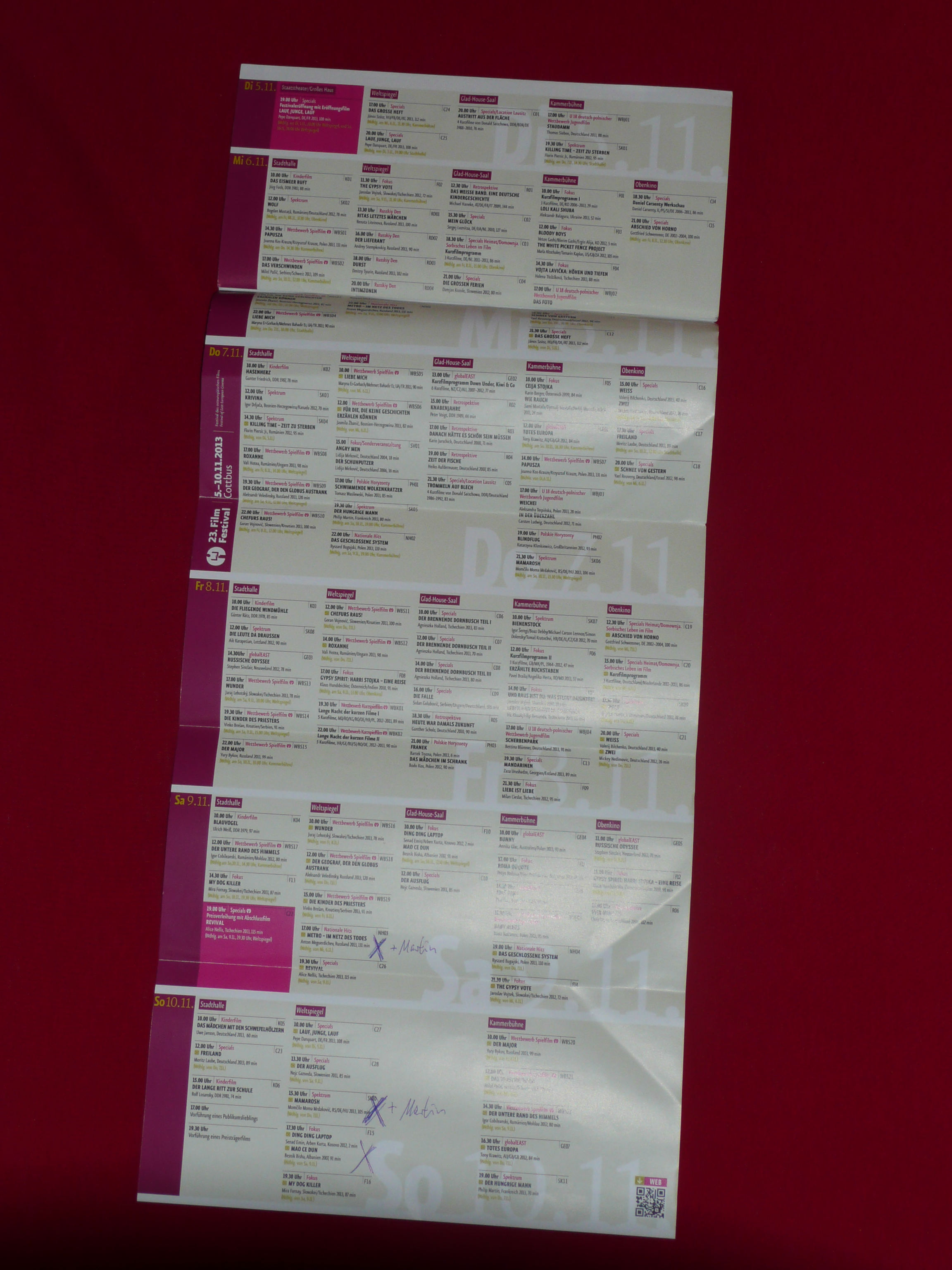 Dieses Jahr markiert für mich einen persönlichen Tiefststand beim Festival des osteuropäischen Films in Cottbus. Mal abgesehen von den paar Malen, wo ich gar nicht in Cottbus war, habe ich glaub ich noch nie so wenig Filme auf dem Plan gehabt wie dieses Jahr. Ich war die Woche über im Feld, so daß die meisten Abende sowieso schon ausfielen. Dann hat ein Kollege am Freitag Geburtstag und Wohnungseinzug gefeiert, damit war’s das dann auch mit der Kurzfilmnacht… Übrig geblieben sind drei Filme:
Vorläufiges Ergebnis des Volksbegehrens „Hochschulen erhalten“
Inzwischen dürfte es sich ja rumgesprochen haben, daß das Volksbegehren „Hochschulen erhalten“ leider gescheitert ist. Der Landeswahlleiter hat am 09.10.13 das vorläufige Endergebnis bekanntgegeben. Demnach sind 18032 Stimmen (0,90% der Stimmberechtigten) zusammengekommen.
Wie zum Zwischenstand habe ich die absolute und prozentuale Ergebnisse in den Landkreisen dargestellt. Allerdings gibt es diesmal keine Informationen zu den „Top-5-Gemeinden“.
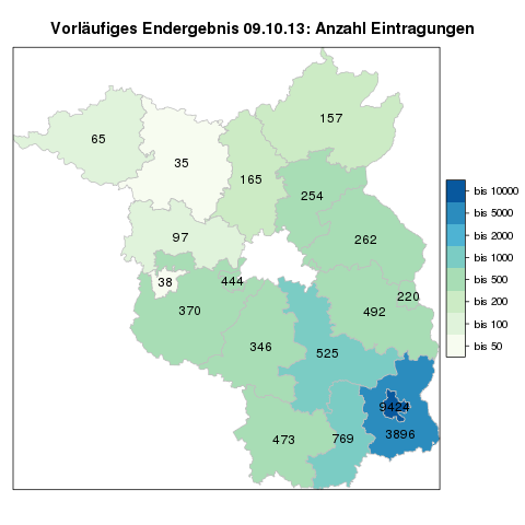
Vorläufiges Ergebnis Volksbegehren: Anzahl der Eintragungen
Bei der prozentualen Stimmbeteiligung mußte ich immerhin die Skala leicht erweitern.
50. Jahrestag des Bergrutsches und Flutwelle von Vajont
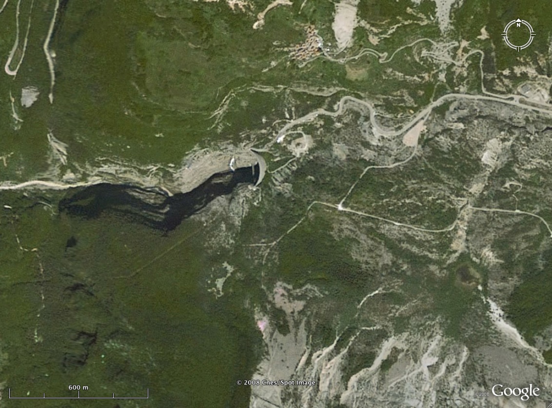
Heute vor 50 Jahren ereignete sich im Vajont-Tal in Norditalien ein schwerer, durch den Betrieb eines Stausees verursachter, Bergrutsch. Die dadurch erzeugte Flutwelle forderte über 2000 Menschenleben. Daran erinnert wurde ich durch Tweets von David Bressan und Scilogs bzw. Michael Khan mit Links auf ihre Blogartikel. Auf Geobulletin fand ich hingegen erstaunlicherweise nichts.
David Bressan hat letztes Jahr in seinem Blog „Geschichte der Geologie“ einen kurzen Beitrag mit einem Link auf eine dreiviertelstündige Dokumentation geschrieben. Der Beitrag ist eine Zusammenfassung eines deutlich ausführlicheren, englischen Artikels in seinem Scientific-American-Blog.
Ich hatte dazu zum 45ten Jahrestag das WoGE 143 gepostet; in den Kommentaren finden sich auch noch ein paar Informationen und Links.
Michael Khan bei scilogs.de hat heute dazu gebloggt und weist darauf hin, daß es nicht ein rein geologisches und technisches Versagen war, sondern auch der Politik; die staatiche Kontrolle und Sicherung des Gemeinwohls wurde dadurch behindert, daß der Staat Eigentümer des Energiekonzerns war. Zukünftig können solche Konflikte bedeutender und größer werden, weil für die Grundlastsicherung wegen der die Zunahme von Wind- und Solarenergie neue und große Speicherkraftwerke nötig werden. Auch findet er es bedenkenswert, daß eine Katastrophe dieses Ausmaßes in den Medien kaum Erwähnung findet und in der Allgemeinheit kaum bekannt ist, im Unterschied zu zahlreichen Unglücken in chemischen Anlagen oder Atomkraftwerken.
Ergänzung 10.10.13, 0:05: Die FAZ hat heute einen Artikel dazu, die Süddeutsche einen von 2010.
Nur wenige überraschende Erkenntnisse durch Wahlunterstützungssysteme
Für die anstehende Bundestagswahl stehen seit einiger Zeit diverse „Wahl-Entscheidungsunterstützungssysteme“ bereit. Nebst dem bekannten Wahl-O-Mat der bpb habe ich noch den Wahlthesen-Test der Süddeutschen Zeitung, das Wahlnavi von Deutsch Plus und Migazin, den Direktkandidatencheck von Abgeordnetenwatch und Spiegel, und „Wen Wählen?“ vom FiTUG ausprobiert. Die meisten habe ich zweimal benutzt – vor einiger Zeit (Ende August, Anfang September) und die letzten Tage nochmal. Bei manchen konnte man Fragen stärker gewichten, dabei habe ich manchmal zwei Varianten durchgespielt. Ein ärgerliches Problem bei allen diesen Seiten (außer „Wen wählen?“, mit Einschränkungen) ist, daß man sein Ergebnis (und die zugrundeliegenden Antworten) nicht abspeichern kann. Das macht Vergleiche schwierig.
Nun mal ohne viele Kommentare ein Blick auf die Ergebnisse, die mich zwar manchmal überrascht, aber meist auch bestätigt haben.
Post von der Polizeiwache Neuland
Die brandenburgische Polizei ersucht Dirk Olbertz, den Betreiber von blogger.de um Bestandsdaten wegen eines beleidigenden Kommentars auf blogger.com:
Ich weiß gar nicht, was mich von all den Punkten am meisten erschüttert: dass die Polizei vier Monate verstreichen lässt, bis sie so einen läppischen Brief verschickt, oder dass sie nicht erkennt, dass es sich bei der E-Mail-Adresse offensichtlich um keine personenbezogene E-Mail-Adresse handelt, auch wenn der Bestandteil IRGENDEIN-NAME nach einem tatsächlich existierenden Namen klingt. Oder aber, dass man mich anschreibt, da ich als Inhaber von Blogger.de verzeichnet bin.
Ich finde das wirklich erschreckend und hinterlässt mich wirklich ein wenig ratlos. Denn auf der einen Seite fordert die Polizei umfangreiche Zugriffe auf Daten im Internet (ich lasse das jetzt einfach mal so ungenau stehen), andererseits ist sie in Einzelfällen hoffnungslos mit dem Internet überfordert.
Sowas kann man sich echt nicht ausdenken.
Die Internetwache, meine Güte. Ich hoffe, daß ich nie auf sie angewiesen sein muß.

