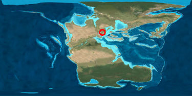
Chris from Good Schist had a nice idea: locate where you (or, more precisely, your bedrock) would have been when the Pangea supercontinent broke up in the late Triassic, 220 million years ago.
Locating southeastern Brandenburg proved a bit difficult, as the late (German) Triassic (“Keuper”) had been a time with varying sedimentation patterns, but mostly terrestric. So here's my guess:
(Image taken from Ron Blakey's great paleogeographic maps.)
Geologic interest in my area focuses on the Cenozoic – Miocene coals and Pleistocene groundwater – long after Pangea's breakup. Therefore I don't have that much information on the Mesozoic here. 🙁 By now, the Triassic rocks have been buried deep down and are only lifted near to the surface at some salt-dome structures. However, the Mesozoic is nicely exposed further to the west/southwest, in the mountain ranges of Central Germany.
I'm not a geologist, only strongly interested in geology. Perhaps the Lost Geologist could correct me and tell more about this – if he could get away from his Gastropods…
Also, I am rather late to the game. (Pangea Day, which was the seed of Chris' idea, has been on 10 May already.) But what are some days in the light of 220 million years? 😉
Other contributions:
- Good Schist (New Zealand)
- NOVA Geoblog (Northern Virginia)
- Clastic Detritus (California)
- Highly Allochtonous (South Africa)
- Hypocentre (Great Britain)


Comments 2
In meinem Fall wäre das dann wohl der selbe Kreis...
Das hatte ich gehofft. Ich war mir über die exakte Lage Berlin/Brandenburgs nicht so hundertprozentig sicher…
Post a Comment