For some time now, I started again with “Where on Google Earth“, with little success, however. (For a description what WoGE is, see below the fold. Previous WoGEs are collected by Felix on his blog and a KML file.)
But now, together with my friend Frank (known in the WoGE Archean as “pl”), I found Ole Tjugen’s last WoGE and could explain its geology. (Which I didn’t manage with WoGE #378.) Salt glaciers in south Iran – an interesting phenomenon which I didn’t know about before.
Now I may come up with a new puzzle. I hope it is something easier, to give newcomers a chance. (Schott’s rule is in effect, see below.)
Where on Google Earth #381. Click to embiggen.
For any new players to Where on (Google) Earth, simply post a comment with latitude and longitude and write something about the (geologic/geographic/hydrographic) feature in the picture. If you win, you get to host the next one.
Because this WoGE should be rather easy, I invoke Schott's Rule: former winners have to wait until posting for 1 hour for each WoGE they got right. I will post some hints if there is no answer after some time.
Posted on 31 May, 16:00 CEST (14:00 UTC).
Have fun and good luck!

Comments 3
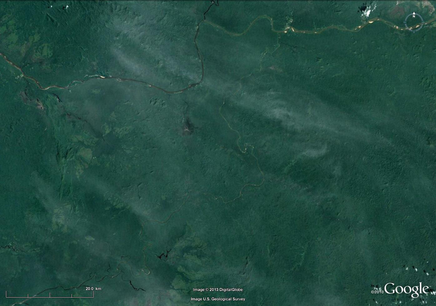
Finding an area this large with so few visible features was quite a feat. By adjusting the contrast a lot, I managed to find out that it was probably on the northern hemisphere, which let me start searching South America from the north. It still took a while before I found
3°N, 66°W - which should be precision enough for this overview.
Finding out what it IS took longer. Finally I spotted a tiny little Wikipedia tag. 🙂
"The Casiquiare river is a distributary of the upper Orinoco flowing southward into the Rio Negro, in Venezuela, South America. As such, it forms a unique natural canal between the Orinoco and Amazon river systems. It is the largest river on the planet that links two major river systems, a so-called bifurcation. The area forms a water divide, more dramatically at regional flood stage."
http://en.wikipedia.org/wiki/Casiquiare_canal
I thought finding an featureless area this large would be easier than finding a small one. 😉
But seriously – the big clue in my opinion was the hydrography. (I even changed my boilerplate text below the image accordingly. *g*) In the southwest corner (near the scale bar), tributaries joining the river running through the centre (the Casiquiare) suggest a flow direction to the SW. Similarily, at the western border tributaries to the E-W river (Orinoco) indicate flow to the west. This is further corroborated by the water colours: in the east of the Orinoco the water is light brown; the tributary from N is dark; in the west, the Orinoco is medium brown, showing that this is the continuation.
So there are diverging flow directions, i.e. a bifurcation. Given the small scale of the image and the absence of large human activities, this must be a big, natural bifurcation. There are not many of these.
(A further hint may be the same colour of water in the eastern Orinoco and the Casaquiare.)
Again, this shows different approaches different people follow and what they judge “easy”.
http://overburdenblog.blogspot.no/2013/06/where-on-google-earth-382.html is up.
One of my candidates for this WoGE involved a river running backwards through its valley, which might be a reason why I tend to distrust the obvious flow directions. So this time there are no rivers. 😀
Post a Comment