Zum zweiten Mal (in Folge) habe ich ein WoGE von Ole Tjugen gefunden. Seine Nummer 382 war – auf den ersten Blick – ein recht offensichtliches Stück schwedische Küste, aber ich hatte die besondere Bedeutung dieser Stelle nicht erkannt. Oles dezenten Hinweis im Text hatte ich überlesen, so daß er mich in die richtige Richtung schubsen musste: die Ytterby Grube, Serienstar aus dem Periodensystem.
Um was es bei Where on Google Earth geht, steht weiter unten. Vergangene WoGEs sammelt Felix Bossert auf seinem Blog und in einer KML-Datei.
Ich bin nicht ganz glücklich mit meinem neuen Bild, weil ich den Copyright-Vermerk unkenntlich machen musste. Aber ansonsten ergäben sich daraus zu viele Hinweise. (Wenn das WoGE gelöst ist, werde ich das Originalbild veröffentlichen.) Damit Neueinsteiger und zu spät gekommene eine bessere Chance haben, gilt Schotts Regel.
Where on Google Earth #383. Zum Vergrößern anklicken.
Für diejenigen, die neu bei Where on (Google) Earth sind: einfach einen Kommentar mit geographischer Länge und Breite (oder eine Ortsbezeichnung) hinterlassen und darin etwas über die (geologischen/geographischen/geomorphologischen) Besonderheiten in diesem Bild schreiben. Der Gewinner darf dann das neue WoGE ausrichten.
In den Kommentaren bitte möglichst englisch schreiben.
Es gilt Schotts Regel: frühere Gewinner müssen für jedes WoGE, das sie erraten haben, 1 Stunde mit der Antwort warten.
Ich werde ein paar Hinweise geben, wenn nach einiger Zeit keine Antwort kommt.
Veröffentlicht am 21.06.13, 23:00 MESZ (21:00 UTC).
Viel Spaß und Erfolg!

Kommentare (3)
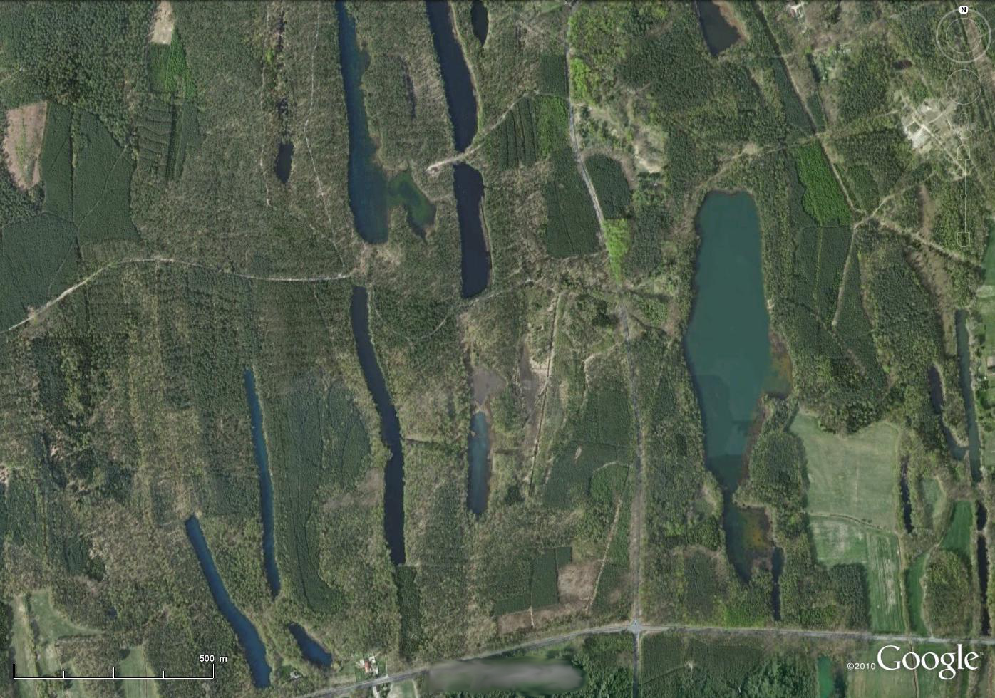
51.5938°, 14.5737° near Lake Felix, Germany
The "Muskauer Faltenbogen" is a glacial structure of the "Elster Kaltzeit" in Europe 320.000 to 400.000 years old (Kansan glaciation). Glaciers clinched the layers of sand and Lignite on a length of 40km to a horse shoe shaped folded structure. Pressure of the glacier and the end moraine deformed the underlying layers to folds.
There is a geological statepart about this: http://www.muskauer-faltenbogen.de/de/muskauer-faltenbogen.html
Lately we do have a lot of geological state parks in Germany. That's a really nice thing to have.
So this is the first WOGE with even my name on it 😀 . Lake Felix .....
Congratulations Felix, for finding this nice structure.
Sadly, that website is a bit lacking, especially in English…
What’s special about the Muskau Fold Arch is not the deformation, but the combination with vasty different weathering rates of the sediments. The layers were not only folded, but thrust, so there are a lot of narrow, almoist vertical coal (lignite) seams. These coal seams lost volume because organic matter is easily decomposed close to the atmosphere, and – in the past few centuries – by mining. This process created the characteristic long narrow “valleys” called „Gieser“, which are often filled with lakes or fens. They nicely outline the Muskau Fold Arch, just zoom out a bit for the bigger picture.
The Felixsee is not in this picture, but not far away. Some years ago a lookout tower was built next to the lake, offering a nice view of the area.
WOGE 384 is at : http://woge-felix.blogspot.de/2013/06/where-on-google-earth-384.html
Kommentar schreiben