Noch ein Hin-Her-Zyklus zwischen Péter und mir. Nach seinen hübschen Mustern der Mäander des Paraná und meiner eher mäßigen Erklärung, ist es Zeit für einen Tag im Meer:
For any new players to Where on (Google) Earth, simply post a comment with latitude and longitude (or a description of the location) write something about the geology. If you win, you get to host the next one.
Again, I think it's not so hard to find, so I'll invoke Schott's Rule: former winners have to wait 1 hour for each WoGE they got right. Additionally, I would look forward to someone else besides Péter answering – just for a change. 😉
Posting time is 21:20 CEST (19:20 UTC).
Good luck!


Kommentare (5)
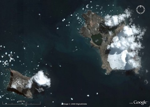
Vindication (left) and Candlemas (right) islands, 57.10S 26.76W, South Sandwich islands. A very interesting place, as the Google map image is the low-res image, whereas Google Earth has just one high res image on top of it.
I must admit I cheated a little bit -- but showing an active volcano so obviously at high latitudes was calling for it. Anyway : http://www.geocodezip.com/v2_activeVolcanos.asp , then selct by regions to see the active volca at high latitude. I first tried the Aleoutians before moving to Antarctica.
Geological description at http://www.volcano.si.edu/world/volcano.cfm?vnum=1900-10=
It appears that the smoke is probably just geyser activity.
Hmm, I'm having problems with this comment. Let's try again.
-57.10
-26.75
South Sandwich islands
Well, I have more details but get an error each time I try to post them...
That's Candlemas & Vindication Islands, in the S. Sandwich. Both are volcanoes, Candlemas had an historical activity in ca. 1910. Apparently the clouds we see are geysers, not a "proper" eruption.
Amusingly, these two island are a high resolution zone in Google Earth in the midst of a mostly low-res region; in Google maps, Candlemas is low resolution too.
I must admit I've been cheating here. An active (or recent) volcano in (obviously) high latitudes is something that must be referenced in databases; for instance, here : http://www.geocodezip.com/v2_activeVolcanos.asp
Actually this specific volcano was not active and therefore is not in the database, but Michael, to the immediate South, is in the base.
Details on Candlemas can be found at http://www.volcano.si.edu/world/volcano.cfm?vnum=1900-10=
JF
Hi Jeff,
congratulations for finding these islands, and sorry for the problems with your comments. Obviously, my spamfilter has put you in the spam queue. (When I began blogging, I didn't even think that such a minor blog like mine would need a spam filter anyway.)
Yes, showing a volcanic island with snow on it was rather easy, but I had a bit of a problem coming up with something more difficult…
Thanks for showing your “alternative” approach to finding this location. I'm looking forward to sharpening my database skills with your WoGE. 😉
WoGE 136 is up.
http://jfmoyen.free.fr/spip.php?article235
Kommentar schreiben