Das letzte WoGE von Felix Bossert hatte ich recht schnell gefunden. (Warum, habe ich in den Kommentaren dort erklärt.) Um was es bei Where on Google Earth geht, steht weiter unten. Vergangene WoGEs sammelt Felix auf seinem Blog und einer KML-Datei.
Jetzt darf ich mir also das nächste Rätsel ausdenken. Wieder möchte ich es etwas einfacher machen (hoffe ich), um auch Neueinsteigern eine Chance zu geben.
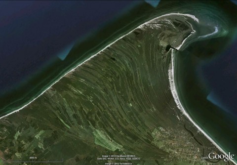
Für diejenigen, die neu bei Where on (Google) Earth sind: einfach einen Kommentar mit geographischer Länge und Breite (oder eine Ortsbezeichnung) hinterlassen und darin etwas über die (geologischen) Besonderheiten in diesem Bild schreiben; in diesem Fall vor allem der Prozess, der zu diesen geschwungenen Linienmustern geführt hat. Der Gewinner darf dann das neue WoGE ausrichten.
In den Kommentaren bitte möglichst englisch schreiben.
Weil dieses Rätsel recht einfach ist, gilt Schotts Regel: frühere Gewinner müssen für jedes WoGE, das sie erraten haben, 1 Stunde mit der Antwort warten. Ich werde ein paar Hinweise geben, wenn nach einiger Zeit keine Antwort kommt.
Veröffentlicht am 18.03.12, 16:00 MEZ (15:00 UTC).
Viel Spaß und Erfolg!


Kommentare (6)
Please note that there's no compass shown – north is not necessarily up…
OK, being labeled explicitly, this is an embarrassingly easy one - perhaps that's why nobody picked it yet 🙂 Since I haven't got any win for ages, here I go:
54.459N 12.507E: This is the Darss-Zingst peninsula in Mecklenburg-Vorpommern, northern Germany, at the southern coast of the Baltic Sea. The southern Baltic Sea coast is shaped by post-glacial sea level rise, land uplift/subsidence, erosion, and transport and accumulation of sediment, forming sandy spits (like this one, called Darss and lagoons ("Boddens" or "Haffs" in German, just south of this view). The present day shape and sedimentary architecture of the forest-dominated Darss-Zingst peninsula are imposed by dominantly west to east longshore sediment transport processes that followed the early Holocene Littorina transgression.
Congratulations, Péter, and welcome back to the game!
How very embarrassing that I missed the „,Geobasis-DE/BKG“ information. Perhaps I should have blurred it until the puzzle was solved.
Sand is eroded and transported at the western coast of the Darß (left in the picture) towards the northern tip, called Darßer Ort (in the top right corner of picture; don't ask me what „das Ort“ means vs. the normal „der Ort“…), behind which it is deposited . (You can see the spit of sand growing out into the water.) Thus beach ridges / dunes (called „Reffe“) and “valleys” („Riegen“) between them are formed. These are visible as curved, linear features in the central part of the picture. At the western end of the valleys there are several small lakes that are slowly transforming to fens by growing full.
The triangular area from the centre of the scale bar to the copyright notices up to the ≈straight line is the “cliff” of the pleistocene island core (Altdarß); the northern part of the island is from the Holocene.
Unfortunately that's a problem of our game. If you have a location in France, Germany, Texas and some other countries, the Copyright informations are quite revealing. I would not remove the copyright informations:
http://support.google.com/earth/bin/answer.py?hl=en&answer=21422
The only thing you can do is to reduce the scale to maybe 1000m, in order to make the game a little bit more difficult, if you have a revealing copyright information.
Florian: very nice location! I found some of these structures all over the world as potential Woge-location, but I've never found out, what formed these structures.
In the past, there were WoGEs with blurred copyright notices until someone had solved them. Then the text was restored. I would have done it the same way, had I realised that they were so revealing.
WoGE#337 is now ready for inspection. Enjoy the quest!
Kommentar schreiben