Sadly, the Wordbooker plugin, which published WordPress posts on Facebook and synchronised the comments, is no longer available. Its author seems fed up with over-demanding users, the changing Facebook API and didn’t enjoy coding it any longer. That’s a pity. Is there a comparable plugin? I don’t want to facebookisise my blog, as the official […]
Nothing much has happened here for quite some time – sometimes due to lack of time, sometimes due to lack of stuff to write about. But in mid-September, my provider disconnected my blog because of a DDos attack, which started to impacted their server.

Just recently, the Landesvermessung und Geobasisinformation Brandenburg (LGB) published the Brandenburg parts of the historic survey by Schmettau. The maps were produced between 1767 and 1787 at a scale of 1:50000. As an example, this is Cottbus and surroundings (link takes you to the Brandenburg-Viewer):
I have read about this, but hadn't watched it yet. I'd better left it at that – this video is really as bad as people say. 🙁 At least the role of the man is limited to passively ogling women…

Since a few days, there's another personal blog by a BTU researcher about the current university politics and Mrs Kunst's (and the ministry's) structure plans: btuinsider.wordpress.com. However, is in German only. Until now, it contains two critical articles (about too-fast implementation and about Mrs Kunst's math skills), but I hope he/she will write more! Update: […]

The EnergyMap project of the Deutsche Gesellschaft für Sonnenenergie e.V. (German Society for Solar Energy) presents the data that is collected as a requirement of the Renewable Energy Act. Sadly, the site is in German only. I'll give some pointers and translations to the interesting areas. The energy map (Energiekarte) shows the distribution of various […]

Some time ago, I've blogged about my stylesheets (CSS) with the colour codes of the International Stratigraphic Chart (ISC) of 2009. For some months now, I own a Palm Pre smartphone (which I am quite happy with) and thought that it would be quite handy) to have this chart on the phone. Of course, you […]
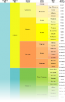
In November 2008, I wrote my stratigraphy stylesheet, which contained colour codes for all units from the International Stratigraphic Chart (ISC) down to the period/system level. Later I added some Cenozoic and Mesozoic units of lower rank. When I was ill during the last weekend and therefore sometimes rather bored, I completed the colour codes. […]
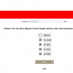
I've bought a “Bavaria Ticket Single” online. Afterwards, I was asked to take part in a little survey. Having time and being in a friendly mood, I agreed. But then, this rather weird questions pops up: Translation: Are you traveling with the Bavaria Ticket Single alone or with several people? alone group of two group […]
Yeah, I feel fast now: 74 words Typing Speed Test And, opposed to German, I even didn't mistype anything; but I'm slower in English. Still, I rank 17535 of 252337, with 393 characters per minute. Oh, sometimes the internet is full of pointless things. 😉
Sometimes, for some equation in LATEX, you need an obscure symbol; but you don't know how it's called. Might happen with over 5900 symbols to choose from. 😉 Without a name, searching the Comprehensive LATEX Symbol List can get a bit tedious. In an older article (German only) at TEX and friends, I've found a […]
I've waited so long for this, and now I've almost missed it: there are some first results from the geoblog survey 2009. Lutz Geißler presents a summary on geoberg.de (and a shorter German version on geonetzwerk.org). Also, there's going to be a publication about it in a not-yet-known journal. It's interesting (similar to the first […]
Change the language with the flags on the top left. Sprache ändern mit den Flaggen oben links.
The new geoblog survey is online this month. This aims at getting a better picture of the geoblogosphere, and to find out what's good, what's bad, what's missing. However, participitation has been low yet. So if you own a geoscience-oriented blog, take this short survey! The survey is open until 1st November.
When preparing my post on the human arm as a geological timescale I looked up the colours for my table from the ICS’s International Stratigraphic Chart. This colour scheme is in turn based on the International Geological Map of the World. The ICS offers both the “official” CMYK and the corresponding RGB colour codes for […]